Please send all News/Events posts on this page to Michael Graser: mgraser114@yahoo.com.
Blog
-
Mary Coffin Obituary
Mary Crittenden Coffin, 81, from Chittenango died peacefully on October 25 under Crouse Hospital life-ending palliative care. She had sudden multiple strokes.
Growing up in a rural family setting she finished high school in LeRoy, NY, college at SUNY Potsdam and her graduate work in science education at Syracuse University. Her 34 years of teaching included East Syracuse Minoa Central School, Syracuse University and on assignment at the U.S. Embassy in Burma. She was cited repeatedly for being an excellent teacher.
She was most active in the Finger Lakes Trail Conference, North Country Trail Association and the Adirondack Mountain Club. Her crowning achievement was leading a scouting team to connect the 4800-mile North Country National Scenic Trail across the entire Adirondacks. She is remembered for her conservation work and teaching it at the Canastota Great Swamp.
Mary led many extended hiking trips across the nation and overseas. She loved scuba diving, hiking, rock climbing and skiing. She was the most considerate and caring person and why so many people loved her.
Surviving is her husband, William Coffin, sisters Margerie Martin and Alice Crittenden, nephew, Eric Crittenden and step-family, William Coffin Jr., Benjamin Coffin, Douglas Coffin, Thomas Coffin and Laura Coffin Bauer. This descends to 8 grandchildren and 6 great-grandchildren.
Mary’s choice for contributions would have included the Crouse Hospital, Francis House, Great Swamp and long-distance hiking trail perpetuity.
-
Northville Placid Trail 100th Anniversary
The Northville Placid Trail is celebrating it’s 100th Anniversary this year. Since its completion in 1924, the 138-mile trail has given hikers—whether through segments or a thru-hike—the chance to immerse themselves in the outdoors: an adventure and an experience that celebrates our public lands. Enjoy many remote and quite lakes and ponds, abundant rivers and streams as you hike this fairly moderate terrain.
Check out it’s 100th Anniversary Web Site.
-
New ADK Leader Certification Requirements
Earlier this spring, 2023, the ADK board of directors voted unanimously to adopt an Outing and Leader’s Guide that establishes organization-wide protocols that will create safer and more enjoyable experiences for our participants. This is the result of a robust year-long process led by the Advisory Council’s Outings and Meetings Committee.
To lead outings in the future, leaders will have to take specific courses and certification programs. The requirements vary depending on the level of the outing. Required leader training is offered at no cost by the ADK or will be reimbursed through the Chapter (contact Chapter Outings Chair for approval in advance of taking the course). A grace period starts on June 1, 2023 which gives leaders the following time periods to acquire these certifications:
Level One: By December 31, 2023
Level Two: By December 31, 2024
Level Three: By December 31, 2024
To learn more about this change, visit the ADK resource page at ADK.org/outing-guide-resources.
Onondaga Chapter Support
For technical assistance with online training and online submittal of certification courses please contact: Jamie Condon, jalynncondon@yahoo.com
For other questions on the new leader requirements, please contact Lisa Druke, lisadruke@gmail.com
Level 1
Sexual Harassment: (annual)
(Onondaga Chapter Recommended) Cornell Cooperative Ext (15 min)
Level 2
Outdoor Leadership 101: (one-time)
Map and Compass: (one-time)
Onondaga’s Jeff Sargent course accepted as equivalent
Basic First Aid: (period of certification varies by provider)
Level 3
Leave No Trace Trainer: (one-time)
Wilderness First Aid: (period of certification varies by provider)
ADK Education will offer 2 in fall 2023; 5 in 2024
Link to ADK certification submission:Trip and Outing Leader Certification Submission
(have your certificates ready to upload by drag and drop in format type pdf, jpg, or png)
Leader Ratings System: click here
Leader certification requirements: click here
-
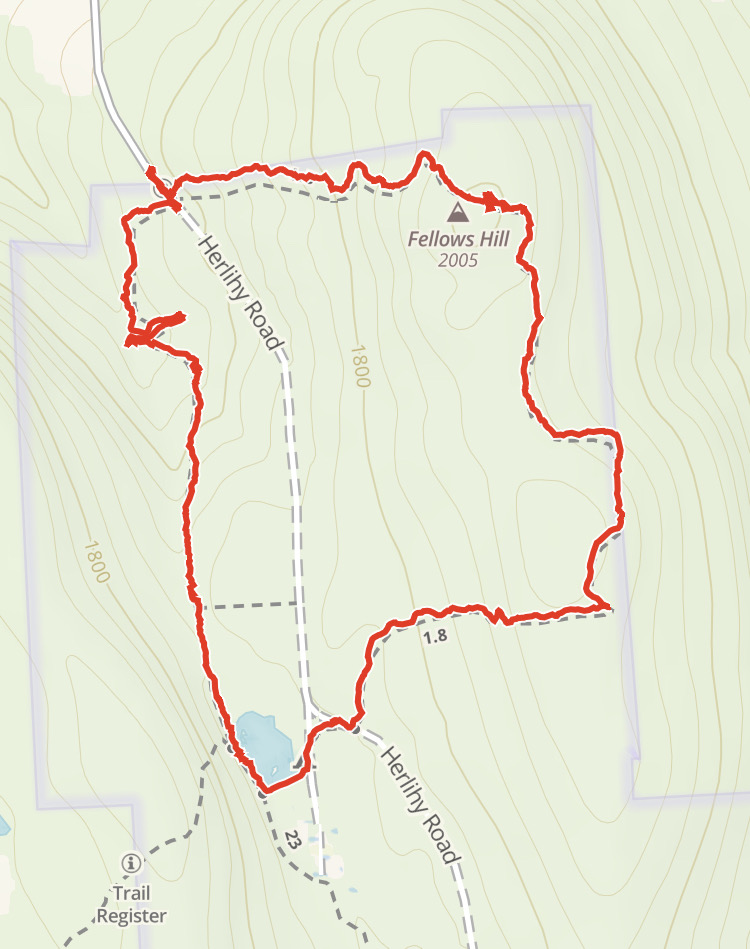
Fellows Hill Loop
Fellows Hill Loop (4 miles, 577 ft. ascent)
Take Herlihy Road from Route 80 near Apulia and park on the west side of the road at the top of the hill.
To walk the trail clockwise, cross the road heading east and up a fairly long hill. At the top of the hill there is a cemetery but no view. The trail heads south descending slightly until curving west and descending more rapidly. There is a junction with Herlihy Road and then a short walk to Spruce Pond. Spruce Pond has a nice log bench for sitting and clear view of the pond. The trail continues along the west shore of the pond, at about midway along the pond, there is t-intersection with the trail heading west up the hill to Jones Hill. To continue on the loop stay along the shore and head into the woods beyond the pond. The trail heads north and then slightly east until you reach the parking area.
-
Five Notable Hikes on the North Country National Scenic Trail in New York State
The Five Notable Hikes of New York’s portion of the North Country National Scenic Trail showcase some of the most expansive and interesting scenery in the state. And, with a hike series beginning in May, trail users can explore all five locations in a group setting with experienced North Country hike coordinators. All five of the notable hikes qualify for the NCTA Hike 100, and Little Rock City, Mitchelsville Gorge, and Tinker Falls also qualify for the FLTC 60. Hikes are free and open to the public.Little Rock City
Little Rock City Road
42.20833, -78.70833 GPS CoordinatesThis 2.6-mile hike (5.2 miles round trip) features a journey through the giant, moss-covered boulders of Rock City and McCarthy Hill State Forests in the southwest corner of the state between Elicottville and Salamanca. The area is a geological wonder, with myriad pathways created for walking amongst the towering rocks
Mitchellsville Gorge
Urbana town hall, 8014 Pleasant Valley Rd., Bath, NY
42.39071, -77.25911 GPS CoordinatesJust south of Hammondsport in Steuben County, this hike on private land features a walk past vineyard on the Keuka Lake inlet and passage through an Eastern Hemlock forest before encountering Mitchellsville Creek and the gorge. The round-trip hike is 4.8 miles and comes with a warning to avoid the now-unstable gorge rim.
Tinker Falls Labrador Pond Overlook
Shoulder of Shackham Rd. off Route 91 between Tully and Fabius
42.76970, -76.01923 GPS CoordinatesThis hike between Tully and Fabius on Route 91 begins with a sturdy climb to the place locals refer to as the “Hang Glider’s Leap” near the summit of Jones Hill, which offers an impressive view of Labrador Pond and the Labrador Unique area as well as most of the Tully valley. This is a hike with options, the most enterprising of which leads back down the hill to the top of Tinker Falls, a 50-foot waterfall with an overhang that can be passed under in spring, summer, and fall. The main loop is a 5.6-mile round trip.
Stone Quarry Hill Art Park
Secret Garden parking at Stone Quarry Hill Art Park, 3883 Stone Quarry Rd., Cazenovia.
This 5.0-mile round trip weaves through the unique setting of Stone Quarry Hill Art Park in Cazenovia and rewards hikers with scenic views of Cazenovia and Oneida Lakes. We will begin with a short loop to a viewpoint in the Art Park, then descend on the North Country Trail through scenic woodlands, crossing small streams, and a wetland before reaching the Chenango St. trailhead in Cazenovia. The return trip will follow the same route with an elevation gain of over 300 feet back to the Art Park. We’ll finish with another loop in the Art Park through some of the park’s unique outdoor sculptures.
Puffer Pond
Old Farm Clearing parking lot
43.70066, -74.1168 GPS CoordinatesThe longest hike in the series, this 11-mile round trip is located in the Siamese Ponds Wilderness in the central Adirondacks near the hamlet of North River. Hikers should be prepared for minor re-routing due to industrious beavers and blowdown. The trail features two lean-tos for rest and snacks, and views of Chimney and Bullhead Mountains.
-
Relics from the Past
Archeology Sites in Central New York – information provided by Bill Coffin and Ed O’Shea. The following is a description of various archelogy sites on or near the Finger Lakes Trail (FLT) System in Cortland, Onondaga, and Madison counties. The latitude and longitude are approximations they should be used along with the maps and descriptions to locate the sites.
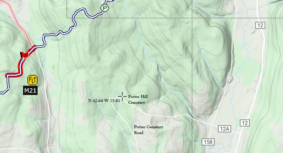
Potter Hill Cemetery is located about one mile south of where the FLT crosses Jipson Hill Road.
Latitude 42.64 N, Longitude -75.91 W (M21)
Randall Hill Water Hole may have been used for fire protection or for horse watering. Latitude 42.68 N, Longitude -74.91 (M21)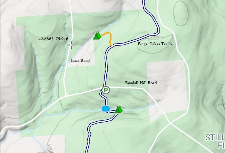
Enze Road Cellar Hole is a half mile west of the Randall Hill section of the FLT.
Latitude 42.6863 N, -75.916 W (M21)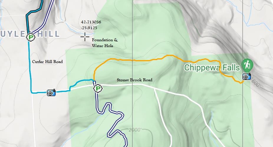
Foundation and water hole is north of Stoney Brook Road. Latitude 42.713 N, -75.9125 W (M21) 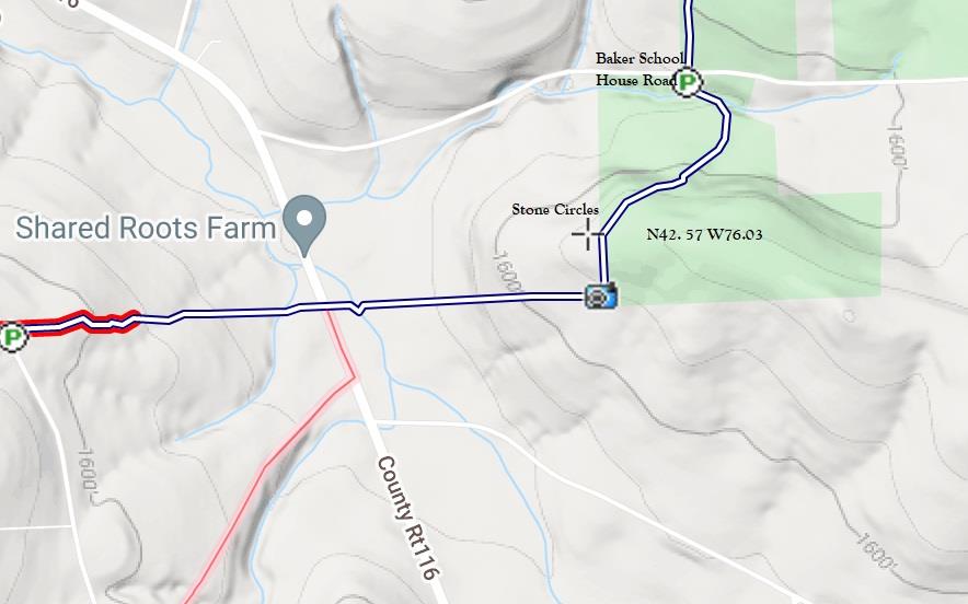
Stone Circles are a short distance from the south side of Baker School House Road after crossing the stream. They are said to have been built by the CCC during the 1930’s for firefighting water. Latitude 42.57 N Longitude -76.03 W (M21) 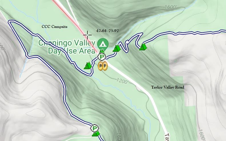
Civilian Conservation Corps (CCC) Campsite was used in the 1930’s and is on the west side of Taylor Valley Road by the day use camp area. Latititude 42.64 N -75.97 W (M21) 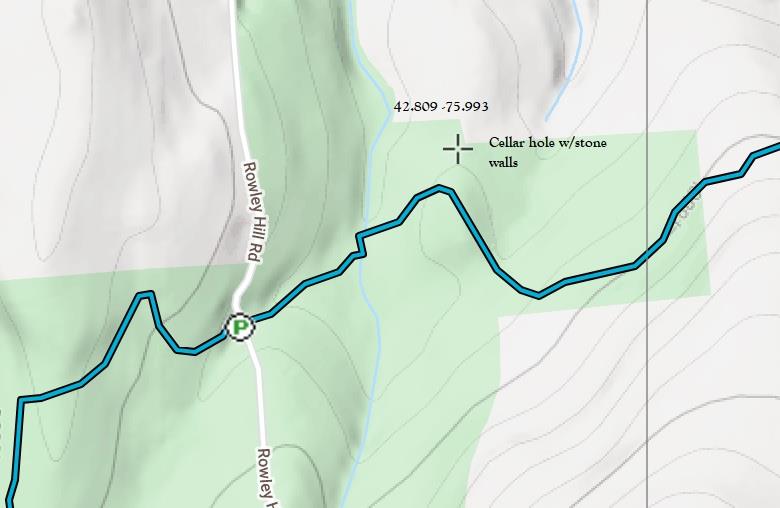
Cellar Hole with stone walls is off the FLT near Rowley Hill Road. To locate the cellar hole, travel east on the trail past Rowley Hill Road and cross the stream. Head up the hill from the stream and to were the trail bends to the right. Latitude 42.81 N -75.993 W (O1) 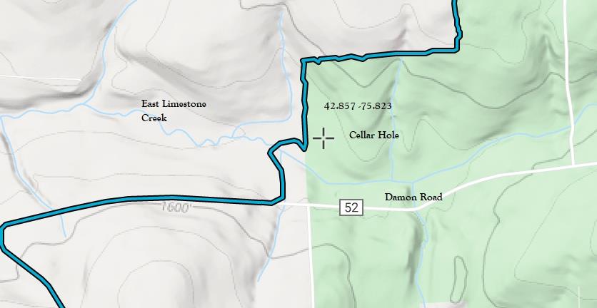
Cellar Hole with stone walls is in Tioughnioga WMA. From the Damon Road trail access, head north and cross the East Limestone Creek. After a short distance the trail turns left and passes through an old apple orchard. Look for a small sign at the celler site on the right of the trail. Latitude 42.857 N Longitude -75.823 W (O2) 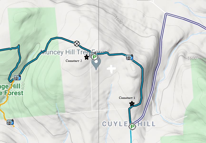
Midlum Hill Cemeteries are located on Midlum Hill. The east cemetery is located off the south side of the trail about 1/10 of mile from Midlum Hill Road. The west cemetery is at the top of Midlum Hill Road on private land a few paces off the trail near the west side of the parking area. (O1) 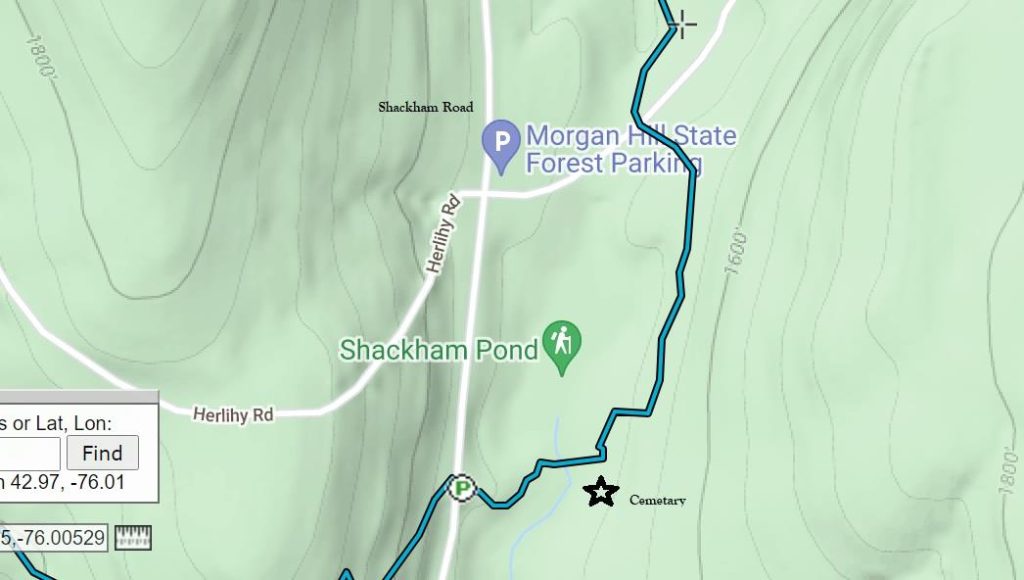
Shackham Pond Cemetery is to the left of the trail on a knoll by the pond shore after crossing the pond outlet stream. Latitude 42.97 N Longitude -76.01 W (O1) -
Solo on the Northville Placid Trail
by Meg Keech, July 2018
“You’re going to do what??” “Won’t you be scared?” “Won’t you be lonely?” These were the reactions I got when I told my non-hiking friends about my plan to do a solo through hike of the Northville Placid trail (NPT), a 135-mile trail running from Northville in the southern Adirondacks to Lake Placid. I can see their point. A woman hiking alone in a wilderness setting is not what a lot of people would choose as an ideal vacation. But for me, it was.
If someone had told me a few years ago that I would be doing this, I would have laughed. Although I have been doing day hikes my whole life, my backpacking experience started only a few years ago. I will never forget leaving from the Upper Works trail head, on route to Flowed Lands, with my (VERY) full pack. After the first 20 minutes I was in tears. I have learned a lot since then.
My training for the NPT consisted of many miles of day hikes, gradually adding weight to my pack, until I was able to hike for 6-7 hours with a full pack comfortably. I also did several overnight backpacking trips, learned how to use all my gear and learned what gear I really needed and what I could live without. As I am sure you have read many times before, reducing pack weight is one of the keys to a successful and happy through-hike experience. The other thing I did to prepare was to study the route, read about the trail, and make a well thought-out plan of how I was going to take on this challenge.
I started my hike at Benson Road rather than at the true beginning of the hike in Northville. I did this to avoid the solo road walk, and also to shorten my hike by 1 day which I needed to do for logistical reasons. My hike from the Benson Road trailhead to Lake Placid took me 9.5 days, including one short 6.0-mile day. My longest day was 16.2 miles. I broke my trip down into three sections, with 2 gear drops, one in Piseco and one in Long Lake. This helped keep my pack weight manageable.
I planned my route to take advantage of the wonderful lean-tos scattered along the trail, although I did carry and use a small tent a couple of times. I carried a small stove, first aid kit, sleeping bag, sleeping pad, food in a bear canister, water filter, and minimal clothes. I also carried a Garmin InReach, so that I could get help in case of an emergency, and could check in with my husband periodically. As luck would have it, on the first night the signal didn’t go through, and he was worried until he heard from me the next day. I also carried bear spray, just in case.
The NPT trail offers a lot of variety. It is overall fairly flat, with small ups and downs to make it interesting. The only real climb is between Tirell Pond and Long Lake, where a steep climb takes you to the highest point on the trail at around 3000 feet. The trail has areas that are very wet. Beaver activity caused some re-routing in places. Overall, the trail is quite well marked, but there are a few places that require a little more awareness to stay on the trail. I carried sections of the guide book, map, and a compass. The description in the guide book helped me a few times in the areas that were less clear. The first section (which I didn’t do) has a creek to ford. The trail goes through the village of Piseco and passes nearby Blue Mountain and Long Lake. It also goes directly through the Wakely Dam area and Lake Durant State Park. Other sections of the trail are more remote including the beautiful Cedar Lakes, West Canada Wilderness, and Cedar Lakes areas, as well as my favorite section, the Cold River area. Beautifully located lean-tos, fabulous swimming opportunities, and a relatively easy flat trail that parallels the Cold River, make this section very enjoyable.
My daily routine was to wake up early, pack up my gear, have a quick breakfast (bar, oatmeal), and then set out on the trail, usually by 6:00 am. I then hiked to my destination, stopping periodically for snacks and short breaks. I went in early July and the deer flies were in full force. This kept me moving at a brisk pace. After arriving at my destination, usually by early afternoon, I would set up camp, do camp chores (get water, hang up clothes, set up bed, put out boots to dry, etc.) and then explore the area and rest. Dinner (hearty rehydrated food) was early—5:00 pm or so, and then I was usually in bed by 7:00 pm. The sleep after a day carrying a full pack is blissful, deep sleep. Was I bored? Not at all. Was I lonely? Not a bit! I met people going both northbound and southbound to chat with along the way. Each day brought new memorable experiences: swimming in the Cold River, seeing otters, sitting in my lean-to and seeing a canine (I think a coy-wolf?) climb out of the water onto the shore not far from me, listening to loons, enjoying a feast in Long Lake, having a hot shower at Lake Durant campground, etc. It also provided me many hours of time to enjoy peace and solitude. Was it all fun and games? No. I fell twice, leaving both shins tattooed with bruises and scrapes. One day I walked in wet boots too long and developed a nasty blister on one toe. The day I hiked between Blue Mountain and Long Lake I cursed the blow down and briefly wondered why I was doing this. But once I arrived at Long Lake and enjoyed a Stewarts hot fudge sundae while chatting with a southbound hiker, I forgot all about that.
Backpack solo might not be for everyone, but for me, the NPT provided a backcountry experience that was both challenging but extremely rewarding. I am going to go back this summer, this time with my husband.
-
Dressing for cold weather hiking.
It’s been so cold the past couple of weeks I thought I should post this as a reminder to all us Winter hikers. To stay comfortable on a cold-weather hike, it’s critical to wear the right clothing and carry the right gear.
Wear layers: Layering is a three-part system that includes a base layer that wicks perspiration away from your skin, a mid layer that insulates you from the cold and a shell layer that keeps wind and moisture out. The goal with layering is to add and remove layers throughout your hike so you can stay warm and comfortable without overheating and getting sweaty. It can feel like a chore to stop and change clothes, but it’s really important to stay dry. Getting wet on a cold day can possibly lead to hypothermia.
Say no to cotton or “cotton kills”: When cotton gets wet, it takes a very long time to dry, which can leave you feeling damp, cold and miserable. Synthetic and wool layers dry much faster and will move perspiration away from your skin.
Cover your skin: Any skin that is exposed to freezing temperatures and cold wind is prone to frostbite. Take special care of your nose, cheeks, ears, fingers and toes.
- For your hands,try wearing lightweight or midweight fleece gloves under waterproof shell mittens or shell gloves. Mittens are better in extreme cold. It’s also a good idea to bring an extra pair of fleece gloves that you keep stowed in your pack in case the ones you’re wearing get wet.
- For your feet,wear synthetic or wool socks that fit well. Thicker socks provide more insulation, but make sure they don’t cause your boots to fit too tight, which can cut off circulation. It’s also important to keep your feet dry, so carrying an extra pair of socks to change into is a good idea. Wear waterproof boots if you’ll be trekking through snow, and if you’ll be in very cold temperatures you might require boots with built-in insulation.
- For your nose and cheeks,try a neck gaiter for face mask. I tried one of these last Winter for the first time hiking the ADK High Peaks. These things are great, I won’t do a winter hike without one.
- For your ears,a winter hat or headband can do the trick. A neck gaiter or face mask may also provide coverage for your ears.
Avoid tight clothing: Wristwatch bands, cuffs of gloves, gaiters and boots that are too tight can cause poor circulation, which can increase your chance of getting frostbite. Make sure your clothing and gear fit properly.
Add heat: Hand warmer and toe warmer packets are a great way to warm up your digits, especially if you’re prone to cold fingers and toes.
Wear a hat: You can lose heat through the top of your head, so pull a winter hat on if you’re feeling chilly.
Keep snow out with gaiters: If your hike will take you through deep snow, gaiters are a must for keeping snow out of your boots. They also add a bit of warmth. Be sure to use waterproof/breathable gaiters for hiking in snow.
Bring goggles or sunglasses: Always protect your eyes from the sun and wind. Many goggles and some sunglasses allow you to swap lenses in and out so you can select the right lens tint for the weather.
Pack a headlamp: If you’re hiking in winter, you’ll have less daylight hours. You don’t have to end your trip when the sun goes down, but you must be prepared to hike in the dark. Have a sense for how many hours of usable daylight you have and always pack a headlamp with fresh batteries. I also carry an extra headlamp.
Keep batteries warm: Cold weather can kill batteries quickly. Lithium batteries tend to hold up better in cold temperatures than alkaline batteries, but no matter what battery type you use, it’s best if you try to keep them warm. From what I’ve found alkaline batteries have a slight amount of moisture in them which can freeze, while the lithium batteries do not. Stowing your headlamp, GPS, cellphone and other electronics in a pocket close to your body can help.
Apply sunscreen: Just because it’s cold out doesn’t mean you stop worrying about sunburn. In fact, if there’s snow on the ground, the sun’s rays can reflect back up at you, so you need to be diligent about applying sunscreen on the underside of your nose and chin and around your neck. I’ve had more severe sunburn in Winter than in Summer back when I was young and stupid.
Bring the Ten Essentials: The Ten Essentials are a collection of items that help hikers be prepared for emergency situations. It’s wise to take these items along whenever you head out for a hike, but perhaps even more so when exploring in cold weather where consequences of a mishap can be more severe. Every hiker should know the Ten Essentials. If you don’t just do a google search to learn more.
Remember there is no such thing as cold weather to hearty Winter hikers, just bad wardrobe choices. Get out and enjoy that snow.
-
Earn this patch for hiking all 41 miles of the Onondaga Trail
Earn this patch for hiking all 41 miles of the Onondaga Trail. (FLT Maps O1 – O2)
To qualify for a free patch you must;
1. Be a current ADK Onondaga Chapter member.
2. Must hike the entire Onondaga Trail, or have hiked it with-in the past 5 years.
To receive a patch email or mail Sigi Schwinge a short description of what you liked best about the trail and the approximate dates that you hike the trail. Email sigischwinge@aol.com Sigi Schwinge 212 Tilden Ave. East Syracuse, NY 13057